Friday, November 25, 2011

Gulf Coast Pure Quartz Sand

On a recent trip to Pensacola Beach, I was amazed at how truly white the sands are on this stretch of the Gulf Coast.  I grew up on the light ruddy brown sand beaches of southern California, refreshed as they are from the crystalline rocks of the Transverse and Peninsula Rages, until recently (geologically speaking) sand delivery was somewhat hampered by flood control efforts.  I now live near the shore of the gray sand beaches of Puget Sound, supplied nonstop by eroding bluffs of glacial outwash sands.  The sands of the Gulf Coast beaches were formed from the wearing down of the Appalachian Mountains, which began their rise some 480 million years ago.  The Gulf of Mexico opened up some 300 million years ago.  The rivers in this neighborhood stopped bringing sand some tens of thousands of years ago.  In sort of a reverse of the Bowen's reaction series, the other mineral grains (e.g. olivines, pyroxenes, amphiboles, mics, and feldspars) weathered and wore down to miniscule particles leaving the highly resistant quartz grains.  This reversal is known as the Goldich dissolution series.  The sand here is almost pure quartz, blindingly white when massed as an endless Gulf Coast beach.
I did see some Deep Horizon oil spill cleanup crews patrolling the beaches in ATVs and just offshore in small skiffs.  I didn't see any evidence of oil spill during my brief beach walks.  I'm sure the oil is out there somewhere lurking.

Saturday, November 19, 2011

Globejotting

For all of you, like me, who have fitfully started keeping a travel journal only to give up around the second day of the trip.  Here's the book for all you erstwhile journalists filled with effective techniques to efficiently maintain a journal without missing a thing on your trip.  Cover the highlights, cut the flab, five a day, and many other techniques presented.  Maybe of real importance is how to elude your inner self as a way toward self-discovery.  I consumed this whole book on a recent flight from Seattle to Dallas-Fort Worth on my way to Pensacola for some project work.  It helped to not have a window next to my window seat; really an annoying let down for any geologist to not have the ability to gaze down at the landscape.  Just a heads up, Seat 10A on an American 737-800 has no window.  At least I got in a lot of reading on that flight.  As it turned out, I kept a journal for the whole week except the last day.  As the book points out, it's OK to go back and journal a long past trip.  Please enjoy this book and don't let another journey go undocumented in your journal.  Start now!

Sunday, November 6, 2011

Coal Trains Running

As I've mentioned in prior posts, I live about 700 feet form the shore of Puget Sound as the Northwestern Crow flies.  Along this shoreline the tracks of the BNSF Railway snake their way from Ballard to Bellingham, never straying too far from the water along this stretch.  I like trains and I like watching them as I stroll along the beach; Canadian lumber heading south, Everett's trash heading to the big landfill in Klickitat County, and the Amtrak Cascades carrying its passengers between Vancouver and Eugene.  It is a small hazard to cross over the double-tracks to clamber down the rip-rap to the beach.  The passenger trains are fast and quiet compared to the freight trains.

In the planning works is a proposed bulk terminal to go in up at Cherry Point, just north of Bellingham in Whatcom County.  The project is known as the Gateway Pacific Terminal and the developer is SSA Marine Services, one of the largest shipping terminal operators and stevedores in the world.  The main bulk product planned for shipment out of this facility is coal extracted from the Powder River Basin in Wyoming and Montana.  The destination for this coal is China.  Why does China want our coal when they have an abundant supply?  The main answer to that question is well explained in this paper: China's Coal Import Behavior.  Basically, it's cheaper for China to buy coal from the Powder River Basin than it is to transport it across China's shaky infrastructure from mine to user.

So why do I care?  Well, on a very local level, there will be increased train traffic along "my" beach and through my bucolic home town of Edmonds.  It potentially means 18 more round-trip trains per day (Everett Herald 5-26-11) and these are long trains, up to a mile and a half.  Whether that ever actually comes to pass is really uncertain given the fickle nature of commodity prices, the instability of coal exports, and whether China finds it cheaper at some point to use their own coal.  China really controls the world coal market now.  Coal export instability and an ill-fated coal bulk terminal at the Port of Los Angeles is discussed here:  Sightline Daily -The Instability of Coal Exports II.

The economics and potential job creation of the Cherry Point project are relevant and must be considered.  However, on a world scale, the generation of carbon dioxide from coal burning and the potential health effect of coal dust generated from a bulk terminal operations and train transport must also be considered.  It will be an interesting couple of years or so as this project plays out.  The opposition has created a website with many good articles and resources here:  Coal Train Facts

On another local level in Whatcom County, Dan McShane discusses the politics (reluctantly) and other implications of the Cherry Point project in his excellent and prolific blog Reading the Washington Landscape.  Some of his Cherry Point related posts:

Kelli Linville: Clearly Opposed to Coal 11-4-11
Coal Politics in Bellingham: Yuk 10-21-11
Coal Stories - Including a Link Showing Local Coal Politics at Work 7-27-11
Coal Politics Comes to Washington and Wonky Process and Diplomacy (update) 6-28-11
Coal Terminal Preemptive Strike 2-28-11

I leave you with the Doobie Brothers:

Saturday, October 29, 2011

Birding Babylon

There's a saying, "wherever you go, there you are."  More to the point, wherever you go, you'll find nature.  I'm always amazed at the tenacity of nature, a weed growing up through the cracked pavement of an industrial landscape, the bee that pollinates the weed flower, the spider hiding in the weed that captures the bee, the wasp that stings the spider and takes it back to its nest to lay an egg to feed its hatching larva.  There you are.  And so it is, in present-day Iraq, that nature perseveres among the explosions and death.  Amid that chaos, Sergeant Jonathan Trouern-Trend kept online journal of his birding and nature observations.  The highlights of these blog posts are assembled in this small book.  Hope springs eternal like the weed that grows up through the crack.

Sunday, October 16, 2011

Fall: On the Beach

It's fall and the Heerman's gulls again make their contrarian fall migration northward from Baja California to our local beaches and elsewhere along the northern Pacific coastline.  Other gulls are here, too, but my identification skills with the other gull species are not so good, especially with the juvenile phases and subtle seasonal variations.  The American widgeons are here and later in the winter we'll see other ducks, the red-breasted mergansers and the goldeneyes, common and Barrows.
I encountered several beached lion's mane jellyfish (Cyanea capillata), the largest known species of jellyfish.  Jellyfish usually die off this time of year as their food supply of plankton dwindles.
Harbor seals are the most abundant marine mammal in Puget Sound.  Harbor seal pups can be found on the beach in the late summer and fall, resting as mother forages.  People may come across a seal pup on the beach and think it is abandoned but it is not.  The pups must not be disturbed.  Seal Sitters is a volunteer group dedicated to the protection of marine mammals in the urban environment along Puget Sound.  I came across a Seal Pup last year but this year I came across one that was unfortunately dead.  Seal pup mortality is relatively high as I understand.

Friday, October 14, 2011

Fall: From the Woods to the Mailbox

We live on the edge of a 120-acre forest of western hemlock, western cedar, and Douglas fir with bigleaf maple and red alder nearing the end of their lifespan.  In another 700 feet as the crow flies is the shore of Puget Sound.  And so we are blessed with a variety of wild plants and animals from rain forest to suburban garden to the shoreline of an inland sea.

Even among the giant trees I'm never at a loss of amazement at the small things.  Walking out to the mailbox I notice a lifeless garter snake on the driveway that was run over by any one of us three neighbors who share this driveway.  I'm not a snake expert but guessing he's a Northwestern Garter Snake (Thamnophis ordinoides), one of several species and subspecies of garter snakes native here.  Its lifeless opaque eyes no longer glisten as transparent windows to his snake spirit.
As I was photographing the snake, along came a beetle, a snail-killer carabid (Scaphinotus angusticollis), attracted no doubt by the scent of the dead snake.  These beetles are pretty common around here and are the good guys that eat snails and slugs.  The beetle's forebody is uniquely shaped to get inside a snail's shell.  Note that the beetle harbors a group of mites seen as the orangish little creatures on the beetle's thorax.
Another common animal is the seldom seen shrew-mole (Neurotrichus gibbsii).  They forage for worms and other terrestrial invertebrates in the shallow soil and leaf letter.  I found this one dead at the edge of the forest.
Fall is also mushroom time, these found growing in our back lawn area, perhaps Mycena sp.
There weren't as may cross spiders this fall as last year, maybe our early November last year freeze reduced their numbers.  It was a cold La Nina last year and this year looks to be a similar La Nina.  We'll see.

Wednesday, October 5, 2011

McIntosh

Back in the Stone Age when I was in college in the late 1970s, I had an introductory computer class where we did goofy little programming assignments using BASIC and working on terminals connected to the college's big Digital PDP-11.  One of my professor's had just purchased a TRS-80, one of the original desktop computers.  I had no clue then how much computers would become literally a household appliance.  After graduating from college I went to work for a huge aerospace company as a manufacturing engineer.  I wrote production planning on a terminal connected to some mainframe elsewhere in the building.  Our group had a secretary who would type letters for us on an IBM Selectric typewriter.  After four years of flirting with the girls on the soldering line, I was beginning to realize that I wasn't really cutout to work in a giant corporation.  But I was liking too much the engineer salary to make a move.   Fortunately, the company made a decision for me and laid me off.  After a few weeks of job searching, interviewing with dreadful manufacturing facilities and sad looking people, I landed a job with an environmental consulting company.  I walked in for the interview and knew right then and there that that was where I wanted to be.  The people were happy and energetic.  The office was quaintly located in the original Sierra Madre city hall and every desk was equipped with a McIntosh 512.  In short time, I was writing reports and drawing plans, all on that little box.  For the next five years, it was nothing but McIntosh's, graduating from the 512 to the SE and later purchasing a McIntosh LC for home use.  It had a color monitor, which was the coolest thing since the Vega-matic.  Somewhere in the early 1990s the company transitioned over to PCs with Windows and that was it.  Pretty soon it was all Windows all the time.

Rest in peace Steve Jobs.  You made some awesome products and brought Apple back to glory with fantastic new products.  History will view you right up there with Leonardo da Vinci as a genius visionary.

Tuesday, April 19, 2011

Manastash Ridge

Sick of gloomy gray skies, I and older son headed over the Pass to the wide open spaces and maybe a little sunshine.  We chose the Westberg Trail, number 9 in the Best Desert Hikes book (Bauer & Nelson), for its nearness and the promise of great views, flowers, and birds.  Geoff, the newly minted driver, got great practice driving freeway for a long distance while I kicked back and enjoyed the scenery.  Obligatory stop in Cle Elum at Pioneer Coffee for a wakeup and Safeway for their signature sandwiches for later lunch on the trail.

The Westberg Trail (aka Ridge Trail) wastes no time in heading directly up 1800 feet to the crest of Monastash Ridge, mostly in open country with generous views over the Kittitas Valley to the cloud-shrouded Stuart Range.  Only the earliest of spring flowers were out; grass widows, gold fields, yellow bells, sagebrush buttercups, and sagebrush violets.  Thankfully no ticks and somewhat disappointingly no rattlesnakes for I love the heightened sense of one’s surroundings that the specter of encountering a rattlesnake brings.


At the top of the ridge, the trail ends at the Westberg Memorial.  The wind was gusting to 22 mph giving a wind chill factor of 33 degrees according to a fancy new toy I bought off Amazon, a Kestrel 2500 pocket weather meter.  We considered following the dirt road that snakes along the ridge to the UW Observatory but first we had to find a sheltered place out of the wind for lunch.  I spied a lone Ponderosa to the lee south out on a side ridge about a quarter mile away.  It was a young tree with branches almost touching the ground offering the promise of a sheltered area out of the wind and so it was.  We enjoyed our lunch there under the tree with the wind rustling the branches overhead and a floor cushioned by pine needles and a few token owl pellets.


From our lunch vantage, we spied a stock pond a little further south down a draw between us and the opposite side ridge.  The power of the pond compelled us and so we packed up and headed to the pond across the open country that offered little resistance to foot travel.  The pond in and of itself wasn’t too exciting except for the large thatch mound of a wood ant colony (Formica rufa) on top of the earthen dam that forms the pond.


Leaving the pond, we followed the trace of a four-wheel drive road back to the main ridge and connecting again with the trail.  Just below the ridge crest, the trail forks near an old broken Ponderosa pine marking the junction to an alternative trail to the bottom.  This trail enters a wooded area of Ponderosa pine and Douglas fir at the head of a side canyon.  Here we flushed a grouse.   The trail follows the canyon all the way down to the irrigation ditch service road and then back to the trailhead.  Near the bottom of the canyon we found a deer skull among the new spring grass, a testimony to the callousness of winter and the promise of spring.


Saturday, February 26, 2011

Bird Boxes

We have two bird boxes around our house.  The ideal time to clean them out is about August or September, right after nesting season.  At work I'm very focused on deadlines and schedules.  At home I downshift into a slower, less frenzied pace.  Because of that, the bird boxes usually don't get cleaned until January or February, just before nesting season.

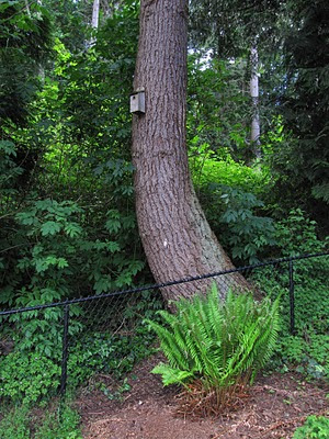
Here's the location of bird box #1, about 12 feet up on the trunk of a large Douglas fir just on the other side of our back fence (photo in May 2010).


Bird box #1 has been used by chestnut-backed chickadees for almost 20 years, except for one year when I didn't clean it out and it was colonized by bumblebees.

Bird box #2 was moved out by our back door last year and black-capped chickadees nested here for the first time.  Before I moved it by the back door it was hanging in an old camellia bush and was used only once by house wrens.


This year's clean out shows the chickadee's nests constructed of moss and lined with soft fuzz and dog hair, no doubt from our dog.


Doing yard work, trimming back western sword ferns that create a fern grotto in a corner of the backyard, I found a couple nests.  These are probably spotted towhee nests, who keep their nests low.  The outer foundation layer is shredded cedar bark then lined with woven grass.

Saturday, February 5, 2011

Driving 99

My interest in old roads goes back to my childhood when I would pack up into the backseat of the 57 Chevy and we'd travel US 66, the Mother Road, from LA to Detroit.  Those trips were epic multi-day journeys on mostly two-lane highways across an ever-changing landscape.  The gas stations were full service.  Stops at Stuckey's yielded their famous pecan logs to enjoy in bits and pieces passed back to me by my mother from the front seat.

On a recent family trip across the western US, we drove the section of Route 66 westward from Seligman to Kingman, Arizona. Once past the kitsch and overly restored Route 66 nostalgia of Seligman, the trip did bring back fond memories of wide open desert valleys and distant mountain ranges as the passing telephone poles counted the way.

Old Highway 99 is the north-south version of the east-west Route 66.   Before Interstate 5, US 99 was the principal north-south highway between Los Angeles on up past Seattle to the Canadian border.  This was the other highway of my youth for our family camping trips to Oregon and Washington.

I get down to Portland occasionally which entails driving Interstate 5 from my homebase in Pugetopolis.  Given time, I'll try to drive a segment of Old 99.  Recently I drove a section of the Old Pacific Highway (99) northward from Kelso to just past the Toutle River reconnecting to I-5 at Exit 52.  The route follows the Cowlitz River and passes through the small town of Castle Rock.

I paused and made a stop where the road crosses the Toutle River to indulge my other interests, bridges and rivers.  The bridge here was constructed in 1935 and was the main route of US 99 until Interstate 5 was completed here in 1969.   With that, the US 99 designation was abandoned in Washington State.

The 1935 bridge is a classic "camelback" truss bridge, specifically a riveted, 10-panel Pennsylvania through truss, a modification of the basic Pratt truss structure.  Evidence of an earlier bridge includes a large piece of concrete pier visible to the left and a stone masonry bridge abutment on the right bank, both in front of the 1935 bridge.  I have been unable, so far, to find any information on an older bridge.


DudeDiligence


 Cowlitz County GIS

When Mount St. Helens erupted on Sunday morning, May 18, 1980, it sent a surge of steaming mud and debris down the Toutle River.  Our 1935 bridge was spared but another road bridge upstream on the North Fork Toutle River was taken out by the mudflow.  The following photo (USGS) was taken from our 1935 bridge shortly after the eruption and looks downstream to the Interstate 5 bridges constructed in 1969.  A mudline left behind on trees shows depths reached by the mud.


USGS

Before heading home, I picked up a few nice, rounded, river rocks for the home landscape.  The rocks are beautiful porphyritic volcanic rocks washed down from Mount St. Helens.

Sunday, January 23, 2011

Glacial Erratics

I'm inspired to share my experience with glacial erratics from reading Dan McShane's blogpost A Really Big Erratic White Rock in Jefferson County (1/20/2011) and Dave Tucker's blogpost Appeal to Citizen Scientists: Do you know of any Jackass conglomerate erratics? I could probably safely say that I've known some erratic jackasses during my lifetime but have yet to find any Jackass conglomerate erratics.

For the layman, a glacial erratic is a large rock transported some distance by a glacier from the rock's point of origin to the point where the glacier leaves it.  The erratic is usually composed of  a different type of rock than the rock or geologic conditions at its resting place.  It often looks out of character with it's surroundings.  Identifying the erratic's rock type provides clues to its point of origin and the sense of the glacier's movement (i.e. direction, distance).


My first sighting of glacial erratics was during numerous hikes through the Sierra Nevada in my formative years when I lived in southern California.  The Sierra provide many opportunities to view alpine glacial landforms.  The photo below shows a glacial erratic near Carson Pass.


In spite of the dense tree cover and dense development, glacial landforms are much in evidence in the Puget Sound region, and this includes large glacial erratics.  I live within spitting distance of the Puget Sound shoreline along Browns Bay north of Edmonds.  My favorite erratic is found along the shoreline here.  Call it the "home erratic" if you will.  At the highest tide it is almost covered providing a safe perch for herons and gulls.  At the lowest of the spring tides the entire rock is exposed.  I'm told by a diving friend that similar large rocks exist just offshore here.  I'm inspired now this coming spring to chip off a piece to see what type of rock it is.